Tools and utilities
Soil Texture Triangle
Particle size class estimator
Here is a tool that allows you to estimate the particle size class of a soil sample from the proportions of sand, silt and clay. The estimator is based on the texture class intervals of the Soil Survey of England and Wales - note that other international standards also exist, such as the USDA and FAO triangles.
Enter soil sample proportions:
Digital Soil Dataset Pricing Utility - Grid Reference Help
How to work out a National Grid Reference
Conversion of two-letter codes to numbers
This pricing guide utility provides you with a price for the different data products which we commonly lease.
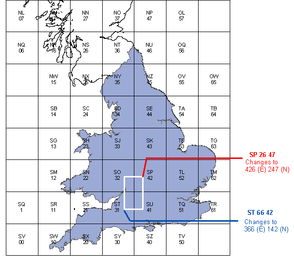
If you have a Grid Reference with two letters out the front, this is how to convert them to numbers.

EXAMPLE 1 - Letters and numbers to 6-figure (1km) grid reference
NS 306834 (This is a single point)
Split the numbers in half...
- NS 306 834
- 306 is the Easting, 834 is the Northing.
Look up NS in the table, below...
- NS = 26
- 2 is the Easting, 6 is the Northing.
Attach the number to the front of the appropriate value...
- 2306 (Easting) 6834 (Northing)
But, you put into the soil data pricing utility only the first three values, as only 1km accuracy is required.
- You would put 230 in the Easting field, and 683 in the Northing field.
EXAMPLE 2 - 12 figure (1 meter) grid reference to 6-figure (1km) grid reference
278456 456390 (This is another single point)
This one is easier as we only need the first three numbers from the Easting and Northing.
- In this case 278 is the Easting, and 456 is the Northing.
OS letter codes to numbers conversion table
| Number (1) | Letters (1) | Number (2) | Letters (2) | Number (3) | Letters (3) |
|---|---|---|---|---|---|
| N02 | HL | 38 | NJ | 13 | SG |
| N12 | HM | 48 | NK | 23 | SH |
| N22 | HN | 7 | NL | 33 | SJ |
| N32 | HO | 17 | NM | 43 | SK |
| N42 | HP | 27 | NN | 12 | SM |
| N01 | HQ | 37 | NO | 22 | SN |
| N11 | HR | 47 | NP | 32 | SO |
| N21 | HS | 6 | NQ | 42 | SP |
| N31 | HT | 16 | NR | 1 | SQ |
| N41 | HU | 26 | NS | 11 | SR |
| N00 | HV | 36 | NT | 21 | SS |
| N10 | HW | 46 | NU | 31 | ST |
| N20 | HX | 15 | NW | 41 | SU |
| N30 | HY | 25 | NX | 0 | SV |
| N40 | HZ | 35 | NY | 10 | SW |
| N52 | JL | 45 | NZ | 20 | SX |
| N51 | JQ | 59 | OA | 30 | SY |
| N50 | JV | 58 | OF | 40 | SZ |
| 9 | NA | 57 | OL | 54 | TA |
| 19 | NB | 56 | OQ | 64 | TB |
| 29 | NC | 55 | OV | 53 | TF |
| 39 | ND | 65 | OW | 63 | TG |
| 49 | NE | 14 | SB | 52 | TL |
| 8 | NF | 24 | SC | 62 | TM |
| 18 | NG | 34 | SD | 51 | TQ |
| 28 | NH | 44 | SE | 61 | TR |
| 50 | TV | ||||
