National Soil Map of England and Wales - NATMAP
Information on NATMAP data products
NATMAP - the National Soil Map of England and Wales

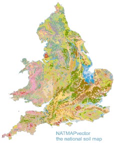
More than 200 man years of fieldwork went into the creation of the National Soil Map. Redigitisation in 1999 resulted in a new vector data set with full urban soil linework and accurate registration to the OS 1:50,000 base (NATMAP vector). NATMAP vector is the principle data product we hold, and displays the 300 mapped soil associations at a scale of 1:250,000.
From NATMAP vector, other digital products have been derived. There are 1 and 5 km2 “gridded-vector” reclassifications of NATMAP vector, named NATMAP 1000 and 5000 respectively. The newest product of the NATMAP range is NATMAP soilscapes. Having only 27 soil map units, NATMAP soilscapes is proving an increasingly popular dataset for a wide group of users. The aim of the NATMAP soilscapes reclassification and simplification of the NATMAP vector data is to provide extensive, applicable and understandable soil data to the non-soil scientist.
NATMAP data can be supplied for NUTS regions, catchments or other specified areas.
NATMAP Products
There are a range of data products derived from or complementary to the National Soil Map.
- NATMAP vector
- NATMAP soilscapes
- NATMAP 1000
- NATMAP 5000
- NATMAP WRB
- NATMAP HOST
- NATMAP topsoil texture
- NATMAP subsoil texture
- NATMAP wetness
- NATMAP available water
- NATMAP carbon
Note also the description of the Soil Classification System for England and Wales, presented here online to accompany the national soil map legend.
About Us
LandIS, or the Land Information System is one of the offerings of the Cranfield Environment Centre (CEC). Incorporating the National Soil Resources Institute, we are the largest UK national and international centre for research and development, consultancy and training in soils and their interaction with the atmosphere, land use, geology and water resources.
Cranfield Environment Centre
Cranfield University
Bullock Building (B53)
Cranfield campus
Cranfield
MK43 0AL
(01234) 752992

Cookies: This site uses cookie. No personal information is gathered or held. You will need to enable cookies for this site to operate correctly.