National Soils Inventory - NSI
NSI Texture Information - NSI Textures

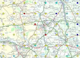
The National Soil Inventory (NSI) textures data is a spatial, point dataset with 6,127 points, located in a 5km grid across England and Wales.
NSI textures provides a very detailed description of the texture of the topsoil. This data, taken from laboratory analysis of the samples from the sites, breaks the topsoil down to its constituent grainsize fraction and provides the percentage of that soil which is of that fraction.
NSI textures can be used to identify areas of topsoil heavily influenced by the presence of clay, silt or sand. This data set will be useful for those investigating the pattern of soil textures across England and Wales, for instance in the relationship between soil and underlying lithology.
How much does this product cost?
- £1,200 for each individual property across England and Wales;
- £15 per point, all data for that point (discounted for more than 50 points);
- £6,250 for the whole dataset.
For detailed pricing information, use our Quotation Advisor utility.
NSI Site data and description
The table below describes the various properties within this data product. Each point contains the information outlined below.
| Property | Example from data | Description |
|---|---|---|
| EAST_NSI | 91000 | National Grid reference easting at 5kmx5km resolution with 1km offset from true grid |
| NORTH_NSI | 11000 | National Grid reference northing at 5kmx5km resolution with 1km offset from true grid |
| CLAY | 3.1 | Clay including CaCO3 (%) (<2μm ) |
| SILT | 10.9 | Silt content (%), including CaCO3, (0.002 - 0.06mm) |
| VFSAND | 5.8 | Very fine sand, including CaCO3 (0.06 - 0.1 mm, 60-100μm) |
| MFSAND | 21.8 | Moderately fine sand (%), including CaCO3, (100-200μm) |
| MSAND | 49 | Medium sand (%), including CaCO3 (200 - 600μm) |
| CSAND | 9.4 | Coarse sand, including CaCO3 (%) (600μm - 2mm) |
Find out nore about soil texture.
