LEACS - Leakage Assessment from Corrosivity and Shrinkage
What is LEACS?
An environment management information system for the water industry

Failures on the water distribution network represent a major cost to any water company. There is a particular interest in understanding the relationship between soil and climate characteristics and failures with a view to predicting areas where the mains and other underground assets could be more susceptible to failure. We have developed a range of research products that provide clear predictable relationship between soils and climate with areas identified as susceptible to risk of corrosion, potentially leading to the incidence of pipe mains failure. The LEACS system for Leakage Assessment from Corrosivity and Shrinkage, is primarily aimed at the water industry, however, LEACS predictions can prove invaluable to any organisation managing underground assets.

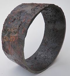
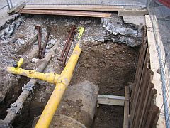
A significant proportion of pipe burst and leaks are associated with the corrosion of cast-iron pipe systems laid without protection earlier this century, but which in many places are now performing so badly that their replacement or repair is a matter of urgency. Replacement is expensive, and to spread the cost and prioritise the worst situations first, there is a need to understand both the degree of intensity of the corrosion process and its spatial extent. Most water companies hold records of pipe bursts and a geographical analysis of these records gives a good indication of where the main problems lie. Often however, knowledge of the boundaries of localities with badly corroded pipes are imprecise. Therefore a rational basis for identifying the extent of potentially corrosive areas offers a valuable tool for reviewing and planning pipework repair or renewal; LEACS offers this. A further addition is a cavity risk index for burst pipes, identifying geographical regions where highly sandy soils are prone to cavitation upon pipe bursts - which can also lead to structural damage.
Leacs is used widely throughout the water utility sector to assist in the Asset Management Planning (AMP) process, as well as by the national regulator the Environment Agency. Leacs is based on CSAI's Land Information System, LandIS, the largest computer-based information system of its kind in Europe.
TopWhat will LEACS do?
How does LEACS work?

LEACS offers a 'geo-spatial' approach, utilising a Geographical Information System (GIS), and allows powerful tools to be employed in modelling an assessment and visualisation of risk of potential mains failure. The LEACS system embodies a number of models and draws upon a wide range of environmental data.
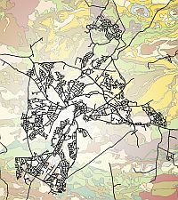
The data in the LEACS system can be superimposed on client Burst locations using a computer-based spatial modelling Geographical Information System (GIS) approach. A statistical analysis of the correlation of burst location with the soils data could be carried out to assist in identifying areas of highest risk.
LEACS data sources
NSRI has been assembling information about the soils in England and Wales for some 60 years and have accumulated an extensive digital database about their properties and distribution. For many parts of the two countries, detailed soil maps and reports have been produced and the whole area is covered by the National Soil Map at a scale of 1:250,000. This map represents a summary of all the data held by Cranfield University, both published and unpublished.
All the datasets are stored in NSRI's Land Information System - LandIS, the largest computer based soil information system in Europe. This includes datasets summarising the properties of all the soil types that have been mapped in England and Wales together with digital images of the National Soil Map and others, the National Soil Inventory and specimen soil profile descriptions and analyses. Values of the soil parameters required by LEACS as recorded in LandIS are incorporated together with assessments of climatic effect, soil shrink swell (or fracture class) and other topographic datasets.
TopThe soil corrosivity model
The impact of aggressive soil waters on ferrous iron

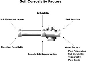
The corrosion of metal in soil is a complex electrochemical process and it is difficult to identify all the contributing factors. There is no national standard for assessing the corrosivity of soil although there are standards for some individual tests and standards produced by interested organisations. The corrosion of underground pipes is a complex electrochemical process influenced by many, often interrelated, soil factors. The soil properties presented here are considered to be the most important in having a significant effect on corrosion rate. These include moisture content; acidity; aeration; and soluble salt concentration.
Using these parameters, five classes of risk are determined, providing a balanced picture. The scoring system is considered the most appropriate system available for this country without the results from direct on-site measurements. This system linked to the soil series concept allows a rapid summary appraisal of any locality or extensive area in England and Wales where CSAI soil data exists. It also ensures that there is a consistent application of soil aggressivity class for similar soils between localities.
The assessments made are based upon the digital version of the CSAI National Soil Map at a scale of 1:250,000. This approach serves well for an overview corrosivity assessment. However, for a higher degree of statistical confidence to be placed in the data interpretation, the assessment can also be conducted with base maps at a scale of 1:50,000, as has been the case in other similar surveys CSAI have undertaken.
Two approaches may be considered to address the required improvement in scale. Firstly, the existing map bases, archive materials and pool of expert knowledge in the Univrsity may be employed to re-interpret the maps to the new 1:50,000 scale. Alternatively, a full ground survey can be commissioned at the scale of 1:50,000; such an approach would have benefits for a wide range of environmental interpretations offered by Cranfield in addition to corrosion risk.
TopPotential LEACS users
Who is LEACS best used by?
The LEACS system has been developed for application across all geographical areas of the United Kingdom. Potential Users of the current LEACS system, and future developments of it include the following:
- The Water Industry
- Water Regulators
- Public Utilities
- The Agrochemical Industry
- Contract Laboratories
- Environmental and Agricultural Consultancies
- Government Departments and Agencies
- Universities, Colleges and other Educational establishments
- Research Institutes
Obtaining LEACS
Contact details
LEACS is used widely within the UK water utility sector as part of the Asset Management Planning (AMP) process.
For further details concerning LEACS, please contact us:
Caroline Keay
Senior Research Fellow in Geospatial Informatics
Cranfield Centre for Environmental & Agricultural Informatics
Cranfield University
Building 53a
Cranfield campus
Cranfield
MK43 0AL
Tel: (01234) 752992
Fax: (01234) 752970
nsridata@cranfield.ac.uk
Personal web page
Institute home page
