LandIS Overview

LandIS Mission
Land resource information
First commenced in the 1970's, Cranfield University's “Land Information System” (LandIS) has provided the basis and repository for holding the digital representation of the soils information collected for England and Wales over the past 60-70+ years. This soil portal provides you with a range of means to access to this information. Cranfield is recognised by Defra as providing the National Reference Centre for Soils, and we apply the information and knowledge encapsulated in LandIS to address the broad range of application areas outlined on this website.
Citing LandIS
A recent academic publication provides details of LandIS, and the ways that Cranfield have developed Land Information System applications worldwide:
Hallett, S.H., Sakrabani, R., Keay, C.A. and Hannam, J.A. (2017) Developments in Land Information Systems: Case studies in land resource management capabilities and options. Soil Use and Management. doi: 10.1111/sum.12380. http://onlinelibrary.wiley.com/doi/10.1111/sum.12380/full.
LandIS Development
Piecing LandIS together

LandIS is the national computerised database system for soil and related land information in England and Wales. It has been developed and maintained since 1987 by NSRI and its forebear organisations the Soil Survey and Land Research Centre (SSLRC) and earlier the Soil Survey of England and Wales (SSEW) with funding from the Ministry Defra, and earlier from the Ministry of Agriculture, Fisheries and Food (MAFF). Responsibility for LandIS now rests within Cranfield's Environmental and Agri-Informatics Institute (CEAI), and Cranfield Soil and AgriFood Institute (CSAI), incorporating NSRI and parts of the Cranfield food science group. During all the periods described here there have been made continuous improvements in the facilities for storage, retrieval and manipulation of soil and land data for the UK. It is the only system of its kind in the UK and is amongst the largest computerised system containing soil and land data in Europe.
LandIS contains information about the soils of England and Wales, collected first by the Soil Survey of England and Wales between 1939-1987, subsequently by the Soil Survey and Land Research Centre from 1987 to 2006, thereafter by the National Soil Resources Institute (NSRI), the Cranfield Soil and AgriFood Institute (CSAI) and the Cranfield Environmental and Agri-Informatics Institute (CEAI). Links with the James Hutton Institute (JHI), incororating the Macaulay Land Use Research Institute (MLURI) in Scotland have led to the compilation of harmonised cross-border datasets for Great Britain, and information from Northern Ireland AFBI may be correlated in the future. LandIS also contains the European Soil Database, a set of digital databases containing key information about the soils of Europe. Close linkages are maintained with the European Union's Joint Research Centre Soil Action team in the Land Management and Natural Hazards Unit.

LandIS information can be related to, and used alongside, other major national environmental databanks, such as the geological information system developed by the British Geological Survey (and its predecessor the Institute of Geological Sciences) and ecological databases established by the Centre for Ecology and Hydrology (CEH), its predecessor, the Institute of Terrestrial Ecology (and its predecessor the Nature Conservancy Council). LandIS also contains data relevant to soil and land studies collected by other organisations, e.g. the UK Meteorological Office and the Ordnance Survey.
The LandIS information base contains large amounts of spatial data about soils, climate and land, and it is unique in its capability to provide these data at field, farm, forest, catchment, regional and national level. The soils data in LandIS plays an important role in informing international studies as well, and the approaches of LandIS have furthermore been adopted in a number of other countries worldwide.

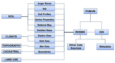
The chart above portrays the broad thematic content of LandIS. Spatial and non-spatial (property) datasets are held for a broad range of environmental themes, the centrepiece of which is the national soil map.
