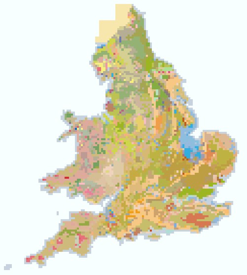
National Soil Map of England and Wales - NATMAP
NATMAP 5000
5km x 5km gridded soils data

NATMAP 5000 is a soil series (soil type) based, 5km2 'gridded vector' spatial data set covering the whole of Wales and England. Natmap 5000 can be supplied as follows:
- NATMAP 5000 - relative % of soil series per polygon
Key Facts and Statistics about NATMAP 5000
- Simplified rendition of the national soil map.
- 297 soil series mapped as either dominant series per 25km2 or relative % of all soil series within the 25km2.
- The soil series percentages are calculated from the percentages of the NATMAP Map units (Soil associations) within the 25km2. This means that the percentages given for the soil series within the polygon should not be taken as precise for that square. They are however, the best estimate available.
Who and what is this useful for?
NATMAP 5000 is useful for anyone wanting a general understanding of the soil series within a region, for those who are not too concerned with actual line work, but only require the overall breakdown of soils within their area.
NATMAP 5000 is ideal for those who want a good impression of the soils covering all of England and Wales, but who have a tight budget.
How much does this product cost?
- NATMAP 5000 - £900 for all of England and Wales.
For detailed pricing information, use our Quotation Advisor utility.
NATMAP 5000 data and description
The table below describes the various properties within this data product.
The table below describes the various properties within NATMAP 5000 (relative % of soil series).
Each polygon contains the information outlined below.
| Property1 | Example from data | Description |
|---|---|---|
| EAST_1K | 426000 | National Grid reference easting at 1km resolution |
| NORTH_1K | 480000 | National Grid reference northing at 1km resolution |
| SERIES1 | ABERFORD | Series name of the domiant soil series |
| SERIES1_PC | 31.8835 | Percentage of the soil association (Map Unit) which is the dominant soil series |
| SERIES2 | EAST KESWICK | Series name of the second most dominant soil series |
| SERIES2_PC | 18.9135 | Percentage of the soil association (Map Unit) which is the second most dominant soil series |
| SERIES3 | ELMTON | Series name of the third most dominant soil series |
| SERIES3_PC | 17.391 | Percentage of the soil association (Map Unit) which is the third most dominant soil series |
| SERIES4 | NERCWYS | Series name of the fourth most dominant soil series |
| SERIES4_PC | 12.609 | Percentage of the soil association (Map Unit) which is the fourth most dominant soil series |
| SERIES5 | DULLINGHAM | Series name of the fifth most dominant soil series |
| SERIES5_PC | 5.797 | Percentage of the soil association (Map Unit) which is the fifth most dominant soil series |
| SERIES6 | ARROW | Series name of the sixth most dominant soil series |
| SERIES6_PC | 4.203 | Percentage of the soil association (Map Unit) which is the sixth most dominant soil series |
| SERIES7 | Series name of the seventh most dominant soil series | |
| SERIES7_PC | 0 | Percentage of the soil association (Map Unit) which is the seventh most dominant soil series |
| SERIES8 | Series name of the eighth most dominant soil series | |
| SERIES8_PC | 0 | Percentage of the soil association (Map Unit) which is the eighth most dominant soil series |
| SERIES9 | Series name of the ninth most dominant soil series | |
| SERIES9_PC | 0 | Percentage of the soil association (Map Unit) which is the nineth most dominant soil series |
| SERIES10 | Series name of the tenth most dominant soil series | |
| SERIES10_P | 0 | Percentage of the soil association (Map Unit) which is the tenth most dominant soil series |
| SERIES11 | Series name of the eleventh most dominant soil series | |
| SERIES11_P | 0 | Percentage of the soil association (Map Unit) which is the eleventh most dominant soil series |
| SERIES12 | Series name of the twelveth most dominant soil series | |
| SERIES12_P | 0 | Percentage of the soil association (Map Unit) which is the twelveth most dominant soil series |
| SERIES13 | Series name of the thirteenth most dominant soil series | |
| SERIES13_P | 0 | Percentage of the soil association (Map Unit) which is the thirteenth most dominant soil series |
| SERIES14 | Series name of the fourteenth most dominant soil series | |
| SERIES14_P | 0 | Percentage of the soil association (Map Unit) which is the fourteeth most dominant soil series |
| SERIES15 | Series name of the fourteenth most dominant soil series | |
| SERIES15_P | 0 | Percentage of the soil association (Map Unit) which is the fifteenth most dominant soil series |
| SERIES16 | Series name of the sixteenth most dominant soil series | |
| SERIES16_P | 0 | Percentage of the soil association (Map Unit) which is the sixteenth most dominant soil series |
| SERIES17 | Series name of the seventeenth most dominant soil series | |
| SERIES17_P | 0 | Percentage of the soil association (Map Unit) which is the seventeenth most dominant soil series |
| SERIES18 | Series name of the eighteenth most dominant soil series | |
| SERIES18_P | 0 | Percentage of the soil association (Map Unit) which is the eighteenth most dominant soil series |
| SERIES19 | Series name of the nineteenth most dominant soil series | |
| SERIES19_P | 0 | Percentage of the soil association (Map Unit) which is the nineteenth most dominant soil series |
| SERIES20 | Series name of the twentieth most dominant soil series | |
| SERIES20_P | 0 | Percentage of the soil association (Map Unit) which is the twentieth most dominant soil series |
| OTHER_PC | 9.203 | Percentage of the soil association (Map Unit) which is made up by other soil series |
| SHAPE | 2 | Feature ID code which links with the spatial description of the data within a geodatabase |
