Case Studies

Soil Erosion as a Feedback System (2023)
Tozer, N. 2024
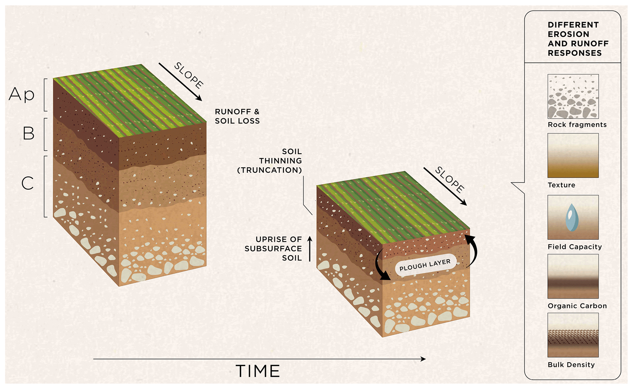
This study, published in Soil [ https://soil.copernicus.org/articles/9/71/2023/ ], investigates soil erosion as a feedback system. Most agricultural soils erode faster than new soil is formed, which leads to soil thinning. Here, researchers used a model simulation to investigate how soil erosion and soil thinning can alter topsoil properties and change its susceptibility to erosion. The study found that soil profiles are sensitive to erosion-induced changes in the soil system, which mostly slow down soil thinning. These findings are likely to impact how we estimate soil lifespans and simulate long-term erosion dynamics.
References:
Palmer, R.C., Beard, G.R., Bradley, R.I., Burton, R.G.O., Harrod, T.R., Hazeldon, J., Hollis, J.M. and Holman, I.P., 2000. Soil Survey of the Isle of Man, Soil Survey and Land Research Centre, Cranfield University, In press.
More Details
Is sustainable agriculture spatially compatible with 'net-zero'? An experimental analysis on the Isle of Man
Undergraduate dissertation project at the University of East Anglia
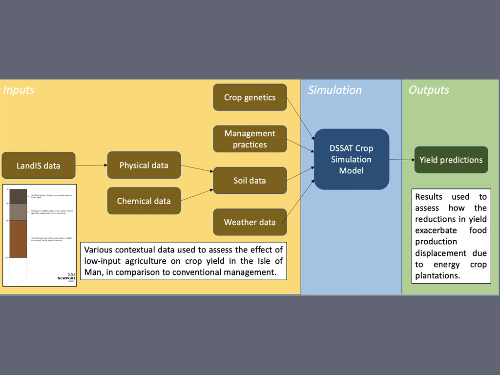
This study assessed how the land requirements of bioenergy generation necessary to achieve net-zero on the Isle of Man might conflict with a scenario of low-input agriculture. To assess how the yields of key crops on the Island would be affected by this change in farming practice, the crop simulation software the Decision Support System for Agrotechnology Transfer (DSSAT) was used. To provide context specific information for the Island, soil and weather data were required. The soil data included a range of chemical and physical information to the horizon level and was amalgamated from a range of data sources. One of these sources was Palmer et al. 2000, obtained through LandIS, which used existing series nomenclature from England and Wales to draw comparisons with auger bores from Manx soils. The dataset showed how texture varied through each horizon, as well as the depth of each horizon. This helped to create 17 key soil profiles, representing the majority of arable land on the Island. Model evaluation suggested that most profiles were a good representation of their relative quality in terms of crop production. This study was innovative in its amalgamation of multiple data sources to create comprehensive soil profiles for the Isle of Man and presents a framework through which different agricultural practices can be tested digitally on the Island without the need of expensive and time-consuming field experiments.
More Details
The long-term impacts of historic landfill waste
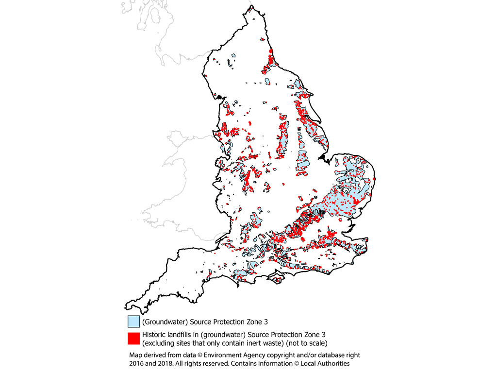
The majority of England's circa 20,000 historic landfills do not have modern-day leachate controls. Brand and Spencer (2023) used NATMAP Soilscapes' data in analysis to determine whether leachates are likely to reach surface or ground waters. They found, 267 of 271 WFD Groundwater Bodies in England are beneath at least one historic landfill in areas with soils that freely drain to groundwater or with naturally wet soils that drain to groundwater. With 167 of England's 425 total catchment (groundwater) Source Protection Zones containing historic landfills with industrial, commercial, household, special, liquid sludge, and/or unknown waste in areas that have soils that freely drain to groundwater or have naturally wet soils that drain to groundwater.
Around 3,700 historic landfills in England are in (groundwater) Source Protection Zones. The majority of these would not be permitted in these locations under current regulations to protect drinking water supplies. This is unlikely to pose a public health risk due to extensive regulatory testing of drinking water, but may increase monitoring/treatment costs or make some sources unviable in the future. This is of particular concern as groundwater sources are expected to become increasingly important in areas where climate change increases the frequency of droughts.
More Details
Towards Indicators of Soil Health
The Environmental Improvement Plan (EIP) (Defra 2023), the first revision to the 25 Year Plan, reiterates the importance of soil and how this vital natural resource will be managed. It sets out a new target to bring at least 40% of England's agricultural soil into sustainable management by 2028 through new farming schemes and increase that to 60% by 2030. The EIP also commits to several factors that will establish comprehensive baseline data including to "establish a soil health indicator under the 25 Year Environment Plan Outcome Indicator Framework".
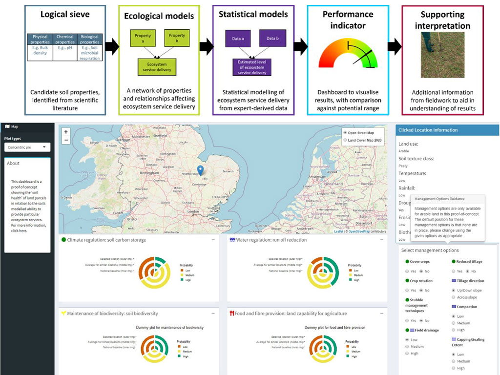
This report sets out the approach which aims to pave the way for an indicator framework of soil health for England. The study developed a concept for soil health indicators and how they could be presented, before trialling the process through a 'proof-of-concept', resulting in an interactive dashboard displaying soils' ability to contribute to the delivery of selected ecosystem services as demonstration indicators of soil health.
More Details